Unveiling the Kok Zhailau Trail
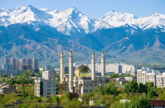
Nestled against the dramatic backdrop of the Tian Shan mountains, Almaty, Kazakhstan, is a city where urban energy meets untamed nature. For locals and a growing number of international visitors, the city’s true appeal lies just beyond its limits, in the network of trails that crisscross the surrounding peaks. Among these, one hike stands out for its accessibility, stunning rewards, and quintessential Almaty mountain experience: the Kok Zhailau Trail.
Welcome to Almaty’s Mountain Jewel
Kok Zhailau, translating to “Green Pasture” in Kazakh, is more than just a trail; it’s a rite of passage for Almaty’s outdoor enthusiasts. It’s a destination that offers a challenging yet manageable ascent, leading to a breathtaking high-altitude plateau. The trail serves as a perfect introduction to the grandeur of Ile-Alatau National Park, showcasing the region’s diverse ecosystems within a single day’s hike. This proximity to a bustling city makes it a unique natural escape, drawing in a significant portion of tourists who visit the area. In 2023, Almaty welcomed over 2 million tourists, with international visitors comprising approximately 27 percent of arrivals. In the first half of 2025, the city attracted 1.1 million visitors, representing a 6.5 percent increase compared to the same period in the previous year.
What Makes Kok Zhailau a Must-Hike Trail?
The popularity of the Kok Zhailau hike is rooted in its perfect balance of effort and reward. The trail is demanding enough to provide a solid sense of accomplishment, with significant elevation gain over a relatively short distance. Yet, it remains accessible to anyone with a moderate level of fitness. The ultimate prize is the Kok Zhailau Plateau itself – a vast, rolling meadow of high-altitude Kazakhstan that opens up to spectacular panoramic views of Almaty spread out below and the snow-capped peaks towering above. It’s a journey through changing landscapes, from shaded coniferous forests to open, sun-drenched ridges.
What This Guide Will Cover: Your Roadmap to the Kok Zhailau Experience
This guide is designed to be your definitive resource for tackling the Kok Zhailau trail. We will dissect the route into manageable segments, providing a virtual map to guide your journey. We’ll offer a granular breakdown of the difficulty levels, explaining what to expect at each stage of the hike. Furthermore, we’ll cover all the practical details: how to get to the Prosveshchenets bus stop trailhead, what gear is essential for a safe and comfortable experience, and the best times to go. By the end, you will have all the information needed to confidently plan and execute your own Kok Zhailau adventure.
Kok Zhailau at a Glance: Overview of the Plateau
Before diving into the specifics of the trail, it’s essential to understand the destination itself. Kok Zhailau is a large alpine meadow and highland pasture, a “jailau,” traditionally used by Kazakh nomads as a summer pasture for their livestock. This expansive, gently sloping plateau is the heart of the hike and the primary objective for most who undertake the journey.
Location and Significance within Ile-Alatau National Park
The Kok Zhailau Plateau is situated within the protected boundaries of Ile-Alatau National Park (also referred to as Ile Alatau National Park), a vast expanse of wilderness that forms the northernmost range of the Tian Shan mountains. Located just south of Almaty, the park is a critical ecological zone, preserving diverse flora and fauna. The plateau’s position provides hikers with an immersive experience of the park’s lower and middle mountain zones. Its accessibility makes it a gateway for many to appreciate the natural heritage of Kazakhstan. In 2025, the Ile-Alatau National Park was among Kazakhstan’s most visited protected areas, welcoming over 500,000 tourists in just seven months.
General Character of the Trail: Scenic Experience and Terrain
The classic Kok Zhailau trail is a well-defined out-and-back route of approximately 10.3 kilometers (6.4 miles) total distance. The journey is characterized by a persistent, and at times steep, ascent with an elevation gain of approximately 880 meters (2,900 feet). The terrain varies significantly, beginning on a paved asphalt road before transitioning to a wide dirt path through a dense forest of Tian Shan spruce (Schrenk’s spruce). As you climb, the forest thins, giving way to open ridges with rocky sections and, finally, the grassy expanse of the plateau. Throughout the hike, the views evolve, from filtered light in the woods to commanding vistas of the city and surrounding mountains.
The hike typically takes 2-3 hours to ascend to Kok Zhailau Plateau at a moderate pace, with an additional 1.5-2 hours for the descent. Alpine meadows and wildflower meadows dot the landscape, particularly during the summer months.
Brief History and Current Status of the Kok-Zhailau Plateau: Development and Environmental Protection
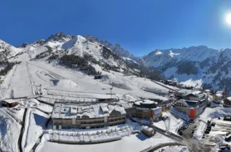
The Kok-Zhailau Plateau has been subject to several development proposals over the past decades. Most notably, a controversial plan to build a large-scale ski resort sparked intense debate and opposition from environmental activists, concerned citizens, and the hiking community who fought to preserve its natural state. In 2019, President Kassym-Jomart Tokayev ordered a halt to the project following unprecedented public opposition, securing the plateau’s status as a protected natural area for public recreation.
However, as of 2025, the development discussion has resurged. In May 2025, the Spanish company Pas Grau Internacional (PGI), a global leader in ski resort development, unveiled plans for Almaty Superski – a large-scale resort spanning Kumbel Peak and the Kok-Zhailau gorge, featuring approximately 65 kilometers of ski slopes. Prime Minister Olzhas Bektenov met with company officials in April 2025 to discuss the Almaty Mountain Cluster project, which aims to expand daily visitor capacity from 6,000 to 10,000. The government has committed to maintaining the protected status of sensitive areas and emphasizes transparency and environmental safety standards comparable to Alpine standards.
Currently, Kok Zhailau remains a symbol of successful environmental activism in Kazakhstan and a cherished destination for hiking and enjoying nature. Hikers should check for the most current trail information and access conditions, as these may change with ongoing development discussions.
Getting to the Trailhead: Access and Transportation
Reaching the starting point of the Kok Zhailau trail is straightforward, thanks to its proximity to Almaty. Whether you opt for public transport or a private transportation option, accessing the trailhead is a simple process.
Primary Access Point: Prosveshchenets Bus Stop
The most common and well-known starting point for the hike is located near the “Prosveshchenets” (Просвещенец) bus stop on Dulati Street. This area, once home to a resort sanatorium of the same name, now serves as the de facto trailhead. From here, the initial part of the journey begins on an asphalt road leading towards the mountains.
Public Transportation: Bus 12 from Medeu Ice Stadium
For those relying on public transit, Bus Route 12 is the key. This bus route runs from a stop opposite the Kazakhstan Hotel in downtown Almaty, up Dostyk Street, and past the famous Medeu Ice Skating Rink (also known as Medeu Ice Stadium). The final stop for accessing the trail is Prosveshchenets. A ride on Bus 12 is an experience in itself, offering a scenic tour through the city’s affluent southern suburbs as it climbs towards the mountains. It’s a convenient and cost-effective option for reaching the hike, with typical fares around 80 tenge.
Driving & Parking Considerations
If you choose to drive, you can navigate directly to the Prosveshchenets bus stop area. Parking is available along the side of the road, but it can be limited, especially on weekends and public holidays when the trail is most popular. It is advisable to arrive early to secure a convenient spot. Be mindful not to block local access roads or driveways.
Starting Points and Initial Asphalt Road Section
Regardless of your mode of transport, your hike will begin from the vicinity of the bus stop. The initial segment involves walking uphill on a paved asphalt road for approximately one kilometer. This road winds past some residential houses and an eco-post (an information station) before reaching a barrier. Just beyond this barrier, the official dirt trail begins, veering off to the right and into the forest, marking the true start of your ascent into Ile-Alatau National Park.
The Kok Zhailau Trail: An Annotated Route Map & Key Segments
The hike to Kok Zhailau can be broken down into five distinct segments, each with its own character and challenges. Understanding these stages will help you pace yourself and appreciate the journey’s progression.
Segment 1: The Initial Ascent from Prosveshchenets (The Forest Zone)
After leaving the asphalt road, the trail immediately enters a dense coniferous forest. This first segment is characterized by a wide, well-trodden dirt path that climbs steadily through the forest zone. The initial section includes a series of steep switchbacks, often referred to locally as the “staircase,” which presents the first real test of your endurance. This challenging section may include stairs with barbed wire (a local safety feature). The forest provides ample shade, making this part of the hike pleasant even on a warm summer day. The path is clear and unambiguous, with the sound of a nearby stream and mountain spring water accompanying you for part of the way.
Height difference during this segment is substantial, and trekking poles are highly recommended for both ascent and descent.
Segment 2: The Valley Climb to the Ridge
As you gain altitude, the trail continues to climb through the forest but gradually shifts into a more open valley. The path straightens out, following the contour of the hillside. The incline remains consistent but feels less intense than the initial switchbacks. This section offers the first clearings in the trees, providing sneak peeks of the city below. You’ll cross a small stream and pass several benches, which serve as excellent rest points. This part of the hike is popular with both tourists and locals, reflecting the diverse crowd visiting the Ile-Alatau National Park.
Segment 3: Traversing the Ridge to the Lower Kok Zhailau Plateau
This is arguably the most scenic part of the ascent. The trail emerges from the dense forest onto an exposed ridge. Here, the landscape opens up dramatically, offering some of the mountain scenery that makes this hike special. To your left, you have uninterrupted, panoramic views of Almaty and the vast plains stretching to the north. To your right, the rugged, higher peaks of the Tian Shan range come into view, including Komsomol Peak (now called Nursultan Peak) and the Big Almaty Peak. The path becomes narrower and slightly rockier in places as it winds along the spine of the ridge, leading you directly towards the plateau.
Segment 4: Exploring the Kok Zhailau Plateau
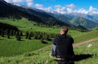
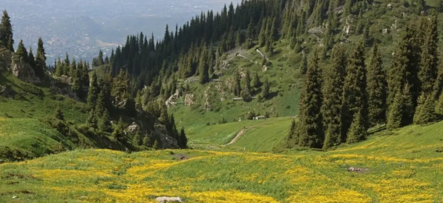
Upon reaching the end of the ridge, you arrive at the edge of the Kok Zhailau Plateau at an elevation of approximately 2,200-2,251 meters above sea level. The trail levels out, and the terrain transforms into a vast, rolling meadow of wildflowers during the summer season. A large wooden swing and several benches mark the main arrival point, offering a perfect spot to rest and soak in the 360-degree views. The plateau itself is expansive, inviting exploration. You can wander across its grassy slopes, find a quiet spot for a picnic, or simply admire the contrast between the bustling city below and the serene mountain wilderness around you.
Segment 5: Descent Options and Return Routes
The most straightforward way to return is by retracing your steps back down the same trail. The descent is significantly faster but can be tough on the knees and quads, so take your time, especially on the steeper sections. Metal shoe chains and trekking poles are recommended for safer footing on the descent.
For more experienced hikers, there are alternative routes. You can continue over the plateau and descend towards the Big Almaty Gorge, or connect to the trail leading to the “Three Brothers” peaks (a summit at 2,850 meters). These options represent more advanced alternatives that require:
- Advanced navigation skills and map-reading skills
- Proper equipment including metal shoe chains
- A higher level of fitness
- Turn-by-turn navigation or GPS devices
- Offline maps downloaded in advance
Additionally, adventurous hikers can extend their journey to Pik Kumbel (Peak Kumbel) at approximately 3,200 meters, which adds 2+ hours to the hike. For most, however, the out-and-back route to Kok Zhailau is the recommended and safest choice.
Decoding Difficulty Levels: A Section-by-Section Breakdown
While the Kok Zhailau trail is widely accessible, a clear understanding of its difficulty is crucial for proper preparation and a positive experience.
Overall Difficulty Assessment: Why Kok Zhailau is Rated Moderate
The trail is consistently rated as moderate. This rating is not due to technical challenges – there is no scrambling or climbing involved – but rather the sustained physical effort required. The primary factor is the significant elevation gain of approximately 880 meters (2,900 feet) packed into a relatively short distance of just over 5 kilometers (3.2 miles) on the ascent. This equates to a consistently steep gradient that will challenge your cardiovascular system and leg muscles. The hike demands a good baseline of fitness but is achievable for most active individuals with moderate hiking experience.
Granular Difficulty Breakdown by Trail Segment
| Segment | Difficulty Level | Key Challenges |
|---|---|---|
| Segment 1 (Forest Ascent – Staircase) | Moderate to Hard | Steepest section with switchbacks; demands high cardiovascular effort; narrow trail in places |
| Segment 2 (Valley Climb) | Moderate | Steady, manageable climb; less intense than Segment 1; focuses on endurance over power |
| Segment 3 (Ridge Traverse) | Easy to Moderate | Gentler incline; main challenges are sun exposure and wind; scenic but exposed |
| Segment 4 (Plateau Exploration) | Easy | Flat or gently rolling terrain; perfect for recovery and enjoyment |
| Segment 5 (Descent) | Moderate | Steep downhill sections put significant strain on knees and quads; trekking poles essential |
“Choose Your Adventure”: Tailoring Your Kok Zhailau Experience
The beauty of Kok Zhailau lies in its flexibility. You don’t have to complete the entire hike to enjoy it.
Beginner/Family Outing
Hike the first segment or two to a scenic viewpoint in the forest zone and return. This provides a great workout and a taste of the mountain air without committing to the full climb.
Standard Hike
Complete the full out-and-back route to the Kok Zhailau Plateau for the classic experience. This is the most popular option and takes approximately 4-5 hours total (including descent).
Advanced Challenge
Use the Kok Zhailau Plateau as a starting point to venture further towards higher peaks like Pik Kumbel or the Three Brothers peaks (requires proper planning, equipment, and advanced map-reading skills).
Essential Gear & Preparedness for the Kok Zhailau Trail
Proper preparation is the key to a safe and enjoyable hike on the Kok Zhailau trail. The mountain weather can be unpredictable, and being well-equipped will make all the difference.
Footwear: Hiking Boots vs. Trail Runners
Sturdy footwear is non-negotiable.
Hiking Boots
Recommended for their ankle support, which is invaluable on the rocky, uneven sections of the trail and during the steep descent. They provide superior protection on technical terrain and distribute weight more evenly.
Trail Runners
A suitable option for experienced hikers with strong ankles who prefer a lighter shoe. They offer excellent grip but less protection and support. Regular sneakers or city shoes are not recommended as they lack the necessary traction and support for mountain terrain.
Clothing: Layering for Mountain Weather (Summer, Spring, Autumn)
The weather in the mountains near Almaty can change rapidly. Layering is the most effective strategy.
Base Layer
A moisture-wicking t-shirt (synthetic or merino wool) to pull sweat away from your skin and regulate temperature.
Mid Layer
A fleece or light insulated jacket for warmth. Even in summer, the plateau at 2,200+ meters can be cool and windy. Afternoon thunderstorms are common, bringing rapidly dropping temperatures.
Outer Layer
A waterproof and windproof jacket is essential. Afternoon thunderstorms are frequent in summer, and this layer will protect you from rain and wind chill. Weather forecasting before your hike is essential – check a reliable weather forecast before heading out.
Bottoms
Comfortable hiking pants or shorts. Avoid cotton (like jeans) as it retains moisture. Breathable synthetic materials are ideal.
Navigation Tools: Offline Maps, GPS, Turn-by-Turn Navigation
While the main trail to Kok Zhailau is well-defined and marked, it’s always wise to have navigation tools as a backup, especially if you plan to explore alternative routes.
Offline Maps
Download the trail map on an app like Komoot, AllTrails, or Wikiloc before you go. This allows you to track your location via GPS even without a cell signal. These tools provide turn-by-turn navigation and can record your trail recording for future reference.
GPS Device
A dedicated GPS device is a reliable alternative for those who prefer it, offering consistent performance regardless of weather conditions.
Signage
The trail is marked with some signs and paint on rocks, but relying solely on these is not advisable, especially during bad weather or low visibility.
Hydration & Nutrition: Water Filter, Snacks, Recommended Water Volume
Staying fueled and hydrated is critical for performance and safety.
Water
Carry at least 2 liters of water per person. There is a mountain spring and water stream partway up the trail, but its reliability can vary seasonally. Bringing a water filter is a good backup to treat water from the stream, ensuring you have access to fresh mountain spring water throughout your journey.
Snacks
Pack high-energy snacks like nuts, dried fruit, energy bars, and a sandwich. You will burn a lot of calories on the ascent, and replenishing them is important for the return journey and maintaining energy levels.
Safety Essentials: First-Aid Kit, Sun Protection, Headlamp, Whistle
Be prepared for minor injuries and emergencies.
First-Aid Kit
A small kit with blister treatment, bandages, antiseptic wipes, and pain relievers. Include any personal medications you might need.
Sun Protection
The sun at high altitude is intense. Bring sunscreen (SPF 30+), a wide-brimmed hat, and sunglasses to protect your eyes from UV radiation and glare.
Headlamp
Essential if there’s any chance you might be on the trail after dark, which can happen if you start late or move slowly. A headlamp with extra batteries ensures visibility and safety.
Whistle
A simple but effective tool for signaling for help in an emergency. The Mountain Rescue Service Station can be contacted if necessary.
Additional Recommended Equipment
Trekking Poles
Highly recommended for both ascent and descent. They reduce strain on knees, improve balance on uneven terrain, and help with stability on steep sections. Many guides include trekking poles with their tours.
Metal Shoe Chains
Useful for icy conditions during spring or after rainfall, providing better grip on wet rock and muddy sections.
Trail Etiquette and Environmental Responsibility
Remember you are a guest in a protected area. With over 500,000 tourists visiting Ile-Alatau National Park in just seven months of 2025, it’s vital to practice Leave No Trace principles: pack out everything you pack in, stay on the designated trail to minimize erosion, and respect the flora and fauna around you. This helps preserve the mountain environment for future generations and protects the wildlife spotting opportunities that make this area special.
Seasonal Considerations and Weather
Best Time to Visit
Summer (June-August)
The best season for hiking. Weather is generally stable, though afternoon thunderstorms can occur. Wildflower meadows are in full bloom, and wildflowers create stunning scenery. Days are long, providing maximum daylight for hiking.
Spring (April-May)
Beautiful emerging landscape with early wildflowers. Weather can be unpredictable with lingering snow at higher elevations. Stream crossings may be swollen with snowmelt.
Autumn (September-October)
Excellent hiking conditions with stable weather and fewer crowds. Mountain scenery transitions to autumn colors. Occasional early snowfall possible at higher elevations.
Winter (November-March)
The area is accessible but challenging. Heavy snow covers the trail, requiring winter hiking experience. The Mountain Rescue Service Station maintains emergency protocols during winter months.
Weather Forecast and Conditions
Always check a detailed weather forecast before your hike. Mountain weather can change rapidly. Afternoon thunderstorms are particularly common in summer. The temperature at the plateau is typically 10-15°C cooler than in the city below, even on warm summer days.
Flora and Fauna of Kok Zhailau
The Kok Zhailau area represents a unique transition zone through multiple ecological levels, supporting diverse wildlife and plant life.
Flora
Trees
The trail passes through dense forests dominated by Tian Shan spruce (Schrenk’s spruce or Picea schrenkiana), an endemic species found only in the Tian Shan and Dzungarian Alatau mountains. These magnificent trees grow at elevations from 1,300 to 3,600 meters and are characterized by their elegant cone-shaped crowns. The forest also includes birch, pine, whitebeam, and aspen trees, creating a diverse woodland ecosystem.
High-Altitude Plants
The plateau supports Sievers apple trees, various wildflower species, and alpine meadow vegetation. Wild herbs including oregano, peppermint, mint, yarrow, and other medicinal plants grow throughout the region.
Fauna
Birds
Over 105 bird species inhabit the area, including the black stork, dwarf eagle, golden eagle, peregrine falcon, eagle owl, and various other species. Bird watching is popular in the region.
Mammals
Mountain goats, roe deer, red pika, gray marmot, wild boar, foxes, and squirrels are common. Endangered species include the Tian Shan brown bear, stone marten, Central Asian river otter, Turkestan lynx, and the iconic snow leopard – the symbol of Almaty, though sightings are extremely rare.
Insects
The area is home to 145 species of diurnal butterflies, 252 species of ground beetles, 110 species of bees, and 97 species of burrowing wasps, including endangered species like the Mountain Apollo butterfly.
Alternative Hikes and Nearby Attractions
Once you’ve conquered Kok Zhailau, the region offers numerous other opportunities for outdoor exploration.
Three Brothers Peaks
Located further along the ridge from Kok Zhailau, the Three Brothers peaks (at approximately 2,850 meters) represent a more challenging extension. This adds 2+ hours to your hike and requires advanced navigation and fitness.
Peak Kumbel (Pik Kumbel)
At approximately 3,200 meters, Kumbel Peak offers experienced hikers a true alpine climbing experience with panoramic views. This extension is for advanced mountaineers only.
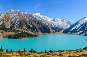
Big Almaty Lake and Big Almaty Gorge
Located in the same national park system, Big Almaty Lake offers a contrasting experience with its striking blue waters and glacial environment. The Big Almaty Gorge and Small Almaty Gorge are also popular trekking destinations.
Nearby Attractions
Shymbulak Ski Resort: One of Central Asia’s premier skiing destinations, accessible year-round.
Medeu Ice Skating Rink: The world’s largest outdoor ice rink, located near the trailhead.
Kolsai Lakes: A stunning multi-day trek featuring alpine lakes at different elevations.
Charyn Canyon: A dramatic canyon landscape southeast of Almaty.
Turgen Gorge: Another popular trekking destination within Ile-Alatau National Park.
Practical Information and Tips
Cost and Permits
The hike to Kok Zhailau is completely free. No permits are required for day hiking within the national park, though a nominal entrance fee (approximately 200 tenge) may be charged at certain access points.
Guided Tours and Tours with Services
Numerous tour operators offer guided hikes to Kok Zhailau, ranging from basic guided tours to comprehensive packages that include transport, meals, equipment rental, and professional guides. Prices typically range from $100-$150 per person, depending on inclusions.
Best Practices
- Start early in the day to maximize daylight and avoid hiking in darkness
- Inform someone of your hiking plans and expected return time
- Respect local customs and wildlife
- Leave no trace: pack out all trash
- Respect the protected area status and stay on marked trails
- Be prepared for rapid weather changes
- Consider hiring a local guide, especially if attempting alternative routes
Conclusion
The Kok Zhailau Trail is more than just a path up a mountain; it is the quintessential Almaty hiking experience. It encapsulates the unique relationship between the city and its natural surroundings, offering a challenging physical journey that culminates in an unforgettable scenic reward. This guide has provided a comprehensive roadmap, breaking down the route, detailing the difficulty, and outlining the necessary preparations.
The key to a successful Kok Zhailau hike lies in respecting the mountain’s demands – understanding the steady elevation gain, preparing for variable weather with proper gear, and ensuring you are well-hydrated and fueled. The mountain offers something for everyone: beginners can enjoy family-friendly sections through the forest zone, intermediate hikers can reach the spectacular plateau, and advanced mountaineers can extend their adventure to higher peaks.
By following this advice, you are equipped not just to complete the hike, but to fully appreciate every segment of it – from the shaded forest paths to the breathtaking ridge traverse and the final, liberating arrival onto the “Green Pasture.” As you plan your Kok Zhailau adventure, your next steps are simple: check the local weather forecast, pack your essentials using our gear checklist, download an offline map of the route using Komoot or AllTrails, and set an early alarm.
Whether you’re seeking wildlife spotting opportunities, mountain scenery that takes your breath away, or simply a memorable mountain trekking experience, Kok Zhailau delivers. The Kók Jailau Trail awaits, ready to offer you one of the most rewarding day hikes in Kazakhstan and a perspective on Almaty you can only earn with effort.